Get detailed information, layer multiple data sources on one map, visually see areas of interest and affecting variables,
generate styled and robust reports and collaborate online with colleagues.
PARCEL DETAILS & OWNERSHIP INFORMATION
One click detailed information on parcel ownership, assessed valuation and boundary maps. We have deeds and taxable entity information as well.
Search Tracts By:
Owner's name, address or legal entity
Property classification
Property & improvement size
Propery value
Nearby traffic counts
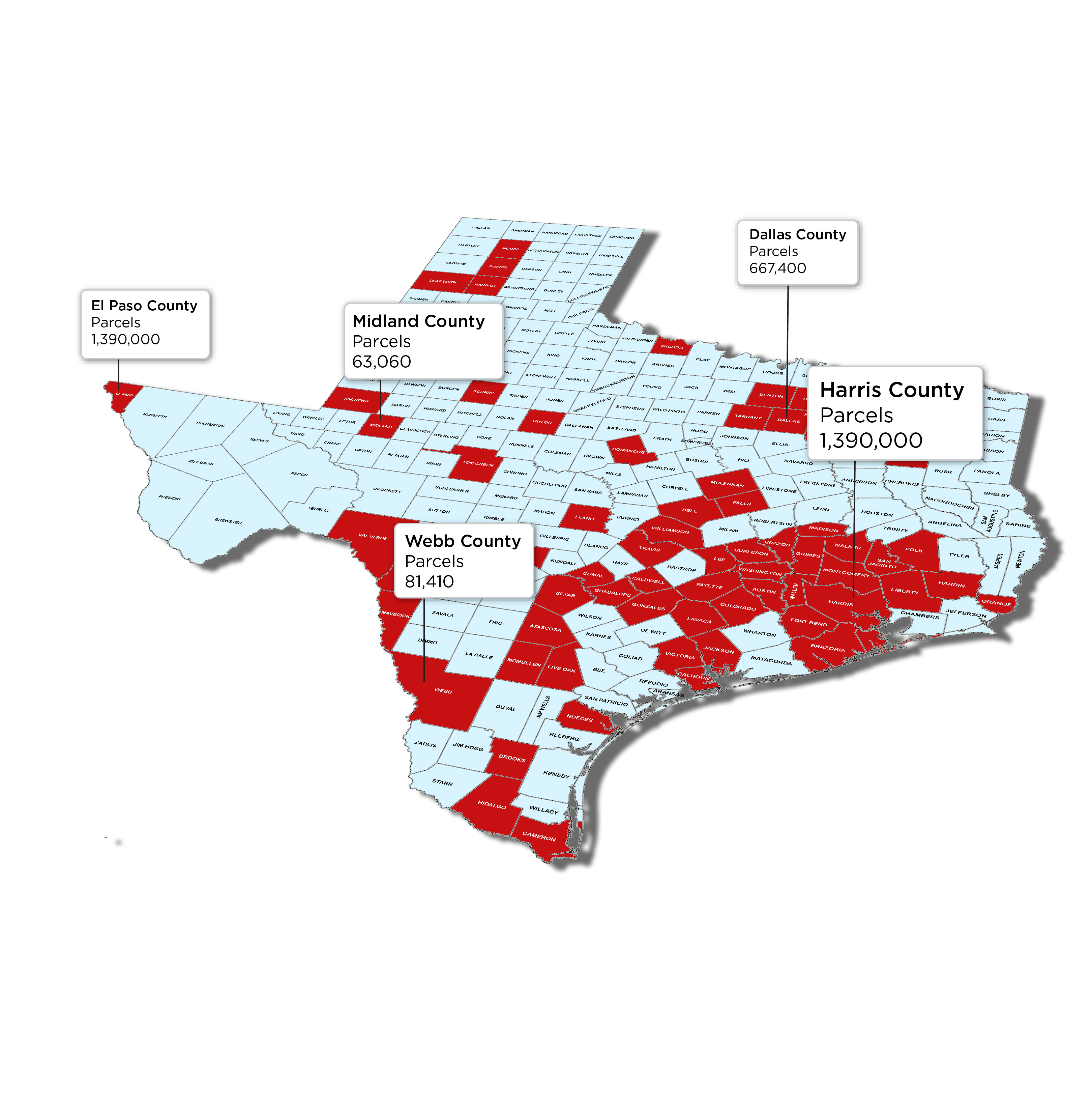
County datasets are constantly being added and updated
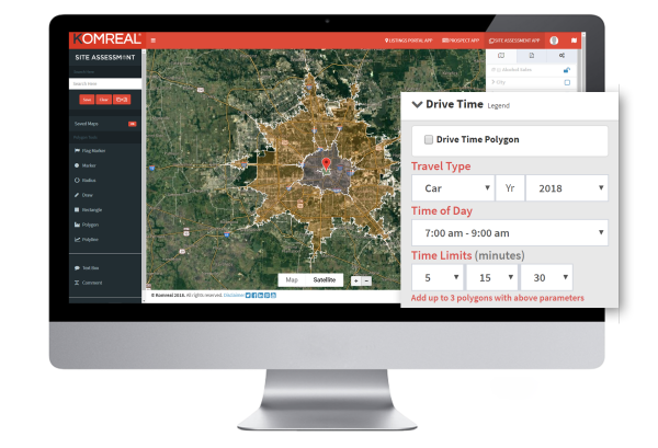
INSTANT TRAFFIC COUNTS, DRIVE TIME POLYGONS & RADIUS RINGS
Analyze traffic counts, create drive time polygons & 1,2,3 mile radius rings.
Drive Time Features:
Choose multiple locations
Choose transportation mode: car, walk or bike
Pick a departure time
Set drive time limits in minutes
Edit colors of each drive time polygon
Isolate and pull reports by drive time
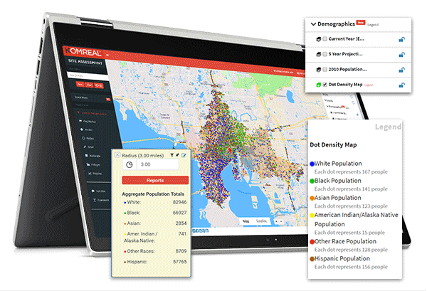
DEMOGRAPHIC & INCOME DATA
Get instant demographics details on any location, anywhere in the nation. Visually see the demographic makeup of people in the United States with our Dot Density Map.
Demographic Date Features:
Heatmap of census blocks
Dot denisty maps for any area in the U.S.
Current year estimates
Five-year projections
2010 Summary data
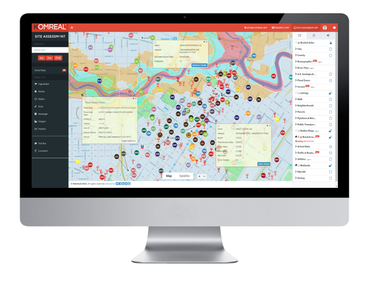
NATIONAL FEMA DATA
Combine floodzone layers with parcels and other layers to make informed decisions. See flood hazard data, get descriptions on each flood zone layer and see where new FEMA map revisions have been made.
Flood Zone Layers Include:
NFHL Availability
Flood Hazard Zones
Firm Panels
General Structures
Water Areas
Water Lanes
LOMR
Profile Baselines
Subbasins
Levees
Transport Lanes
CBRS
Base Flood Elevations
NATIONAL BUSINESS INSIGHT DATA
Search for businesses in multiple categoriers spanning hundreds of industries. Gain valuable insight with geolocation, contact information, number of employess, sales, technology demands, cap rates, stock data and more.
Filter Results By:
Text search
Business category
Geolocation
Estimated annual sales
Number of employees
Building type
Fortune 1000 ranking
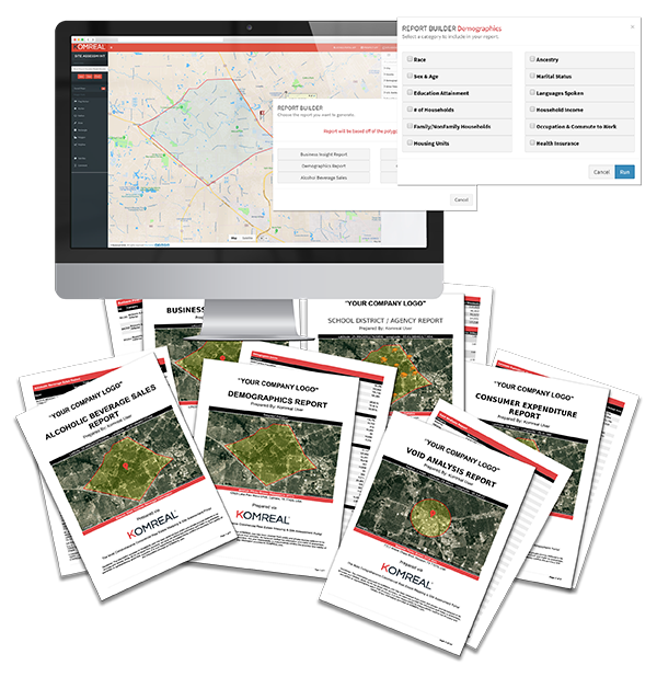
COMPANY BRANDED REPORTS
Generate company branded reports with polygon tools, radiuses, markers or drive times. Access all reports from one window.
Reports Include:
Demographics
Business Insight
Void Analysis
Consumer Expenditure
Alcohol Beverage Sales
School Districts / Agencies
Daytime Population
Industry Growth Potential
Combine All Reports with the all-in-one Site Assessment Report
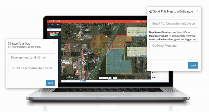
SAVE & SHARE MAPS
Create interactive maps using our comprehensive data layers.
Save maps with a name and description
Instantly share with one or more recipients via email.
Recipients can make revisions to maps & send it back for collaborations.